


Prince William County Map
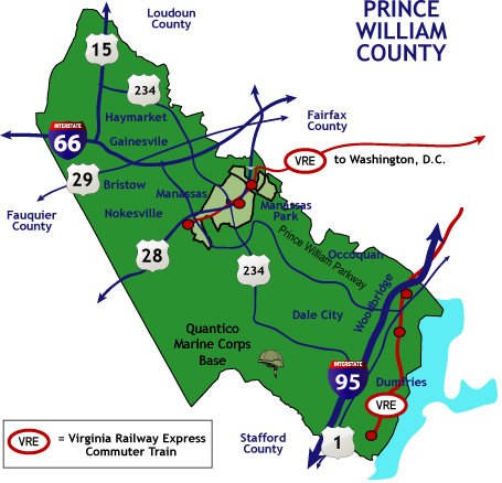
This is a Prince William County map from FrontDoordHomes that is also linked to Google maps, This Prince William County map is a simple real estate map created by FrontDoorhomes to make it easier for you to Search for homes all over Prince William County.
Click Here to do a MAP Search for Homes for Sale
The Prince William County map of FrontdoorHomes also includes Routes, and Virginia Railway Express Commuter Train (VRE) diagrams, and key cities including Haymarket, Gainesville, Bristow, Nokesville, Manassas, Manassas Park, Occoquan, Dale City Woodbridge, and Dumfries. In this Prince William County Map you will also see locations of Prince William Parkway and Quantico Marine Corps Base.
The Map also shows directions that lead to other Counties like Loudon County, Fauquier County, Fairfax County, and Stafford County. So whenever you are planning in moving in to Prince William County, you can take a look at this map to see the neighboring cities and because this Prince William County map is so simple, it is very easy to use and you can easily determine the best strategic location for you and your family when moving in.
FrontDoorHomes also has maps for other counties that you can use similarly like this map, and because it is linked to Google maps, you can automatically switch from a simple map to a more complex map with several user options and you can toggle to satellite image to have a more detailed view and you can also zoom in and zoom out to check on specific area or property.
Since FrontDoorHomes Prince William County Map are linked to Google map it also gives you the freedom to explore more areas that you want to see, and beside the map it also provides picture for landmarks and links to the community websites which allows you to be able to know deeper about the area that you want to live in that’s why it is really beneficial to use our FrontDoorHomes Prince William County Map.